RAGBRAI 2019, day 7: Burlington to Keokuk
 Comments (1)
I began this LAST day of driving the RAGBRAI XLVII (yay!) getting good and lost as I tried to find my way out of Burlington. It was about noon, and I’d just finished the Day 6 route, which went through Geode State Park, Middleton, and West Burlington.
The first part of this last day’s route essentially retraces the previous day’s ride, and I wasn’t too keen on that. I decided I wanted to take the Great River Road to Denmark, the first NEW location on the route.
Finding the Mississippi River road was no easy feat, but I finally got on it with the help of my trusty Iowa Atlas and Gazetteer and a few well-placed U-turns.
As I started this last leg of the route, it occurred to me that it felt like the bicycle ride should be over. I was at the Mississippi, after all, and if I’m not mistaken, Burlington has been the last town on the route half a dozen times. So it seemed weird to have this back-tracky, unnecessarily southern route today.
I will admit I was a little grumpy, too, because I failed to find lunch in Burlington – I guess I didn’t try very hard – and it was really, really hot. And I was in a no-NPR zone.
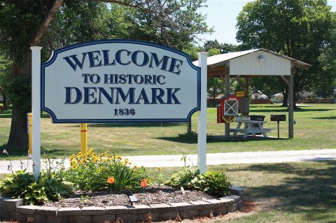
But then I headed into super-cute little unincorporated Denmark, Iowa, and my mood improved. I was tempted to take a book from the little free library in the park, but since I don’t live in Denmark it sort of seemed like stealing.

Heading toward West Point, Iowa, on county roads X32, J48, and J40, I started seeing signs that said “RAGBRAI route – 15,000 bicyclists – plan ahead!” I thought at first that these were the work of the local RAGBRAI committee, but I continued to see them all the way into Keokuk, so they’re clearly the work of the main RAGBRAI organization. I hadn’t seen these in past years, though maybe they went up after I passed through. Doesn’t matter…it’s a great way to warn people to plan ahead.

I also saw some pretty farms and some curvy roads that could be fun for the riders.

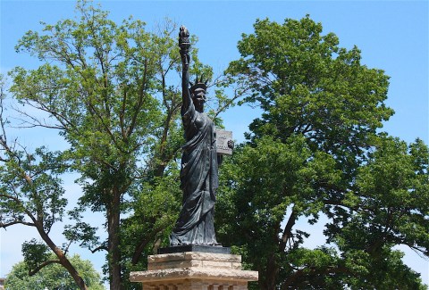
I arrived in West Point (population 954), as patriotic-looking a town as you’ll ever see. The downtown has a lovely park surrounded by historic buildings (and another miniature Statue of Liberty).


The West Pointers also apparently know how to have a good time, with a tavern and biergarten flanking either side of the main business area.

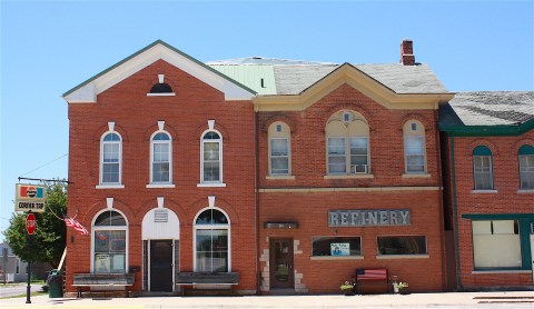
Franklin, Iowa, also has an inviting tavern with outdoor patio space (below).


Just before I rolled into in Donnellson, I received an emergency text alert that all the power had gone out in Ames. Good to know! At this point, it was 95 degrees and I was beginning to melt.
Riders will be more than half-way finished with today’s route when they arrive Donnellson (population 885), the meeting town and home to Lee County fairgrounds:


From Donnellson, they’ll take U.S. Hwy. 218 to Montrose, another river town. When I arrived there, Montrose was in full-blown party mode. Everyone at the Montrose Sandbar seemed to either ride a motorcycle or drive a pickup, so I’m sure my bright orange Prius did not go unnoticed.


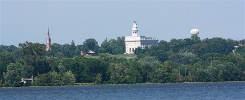
While in Montrose, I was hoping to cross the river to the town of Nauvoo, Ill., to check out the Mormon temple and other historic attractions. There’s a Joseph Smith (founder of the Latter Day Saints movement) historic site, a red brick store, Nauvoo House, Bringham Young Home, and more. I can’t say as I care much about Joseph Smith, but I thought the architecture and history would be fun to see.
I was encouraged to go over to Nauvoo by the woman working at Iowa Visitor Center in Bloomfield earlier on my drive. She gave me a brochure and everything. What she didn’t mention was that there is no bridge between Montrose and Nauvoo. I guess I should have looked at a map, huh? Anyway, it was already late and I just didn’t bother to figure it out. I took this picture from the Iowa side of the river and called it good.
RAGBRAI riders will follow the Great River Road, AKA county road X28, from Montrose to Keokuk, and they’re in for a very scenic ride.
I was eager to visit Keokuk (population 10,780). I’d never been here before, probably because it never seems to be on the way to anywhere I’m going, and because it seems to belong more to Missouri or Illinois than to Iowa. But I’ve always liked river towns, and I’d heard this one had some gorgeous old houses.
Coming into town, I quickly found my way to the downtown area and walked up and down the main street, sweating profusely.


When I got back to my car, I drove to the riverfront to see Lock & Dam No. 19 (above) and the bridge that takes you into Illinois.


In that area, I stumbled on the George M. Verity River Museum (below) and watched barges making their way up the river.


I also found the Keokuk Union Depot (above), built in 1891 and listed on National Register of Historic Places. The depot is a bit of a mess, but it’s currently undergoing a preservation project and the sign says it’s (going to be?) an event center.
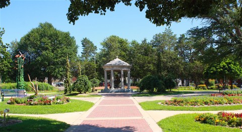
I knew I wanted to go to Rand Park to see the Chief Keokuk statue, but I had no idea what a delightful place this park is. It’s definitely one of the nicest parks in all of Iowa. Besides the statue of Keokuk, a Sac Indian chief, Rand Park is situated on a bluff with a panoramic view of the Mississippi River. There are lovely flower gardens and a lot more – 57 acres total.


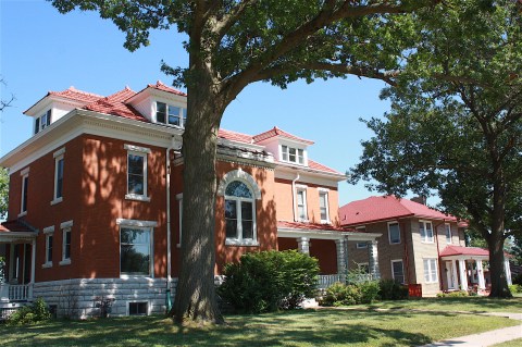
A bonus, as I drove toward Rand Park, was that I encountered the Grand Avenue/Park Place residential area – on the National Register of Historic Places and at the top of my list of things to see in Keokuk. Man, oh, man, these are some stately, drool-worthy old houses. Fifteen blocks worth of grand homes! I parked and got out of my car briefly, but mostly I just drove by as many as I could.

Oh, before I finish up, here are some fun facts about this town:
- Keokuk has 20 entries in the National Register of Historic Places.
- The American Fur Company opened a trading post in Keokuk in 1828 that was known as “Rat Row.”
- Keokuk was home to Younkers’ first store, which is now just kind of sad.
- Famous people with Keokuk connections include Mark Twain, Andrew Carnegie, Theodore Roosevelt, Betsy Ross, and Krusty the Clown. (Wait…what???)
I love that last one.
On my drive back to Ames, the heat finally broke. I encountered a rather terrifying storm that nearly blew my little car right off the road around Oskaloosa. But I survived – and saw the temperature drop from 96 degrees to 69 degrees in less than an hour.
With that, another RAGBRAI route drive is in the history books. Thanks for sticking with me!
RAGBRAI 2019, day 6: Fairfield to Burlington

I survived my night at The Rakmapura Park Hotel in Vedic City, just north of Fairfield. My over-active imagination had me on edge, but I was worried for nothing. In fact, I had a very pleasant night and slept much later than I expected.

After I checked out of the hotel (still nobody at the front reception desk), I grabbed a latte and a currant scone (warm from the oven!) at the inviting coffee shop Café Paradiso in downtown Fairfield (top and below).

Before I say goodbye to Fairfield, have I convinced you to visit this town in southeast Iowa? Besides the First Friday Art Walks, you can take in FAIRfest (Labor Day weekend), municipal band concerts (Tuesday nights in July and August), a Live on the Square Summer Concert Series, Farmers Market (Saturday mornings May through October), Oktoberfest (first Friday in October), and a holiday tree lighting (the Friday after Thanksgiving). Or just go for dinner and a stroll any time!

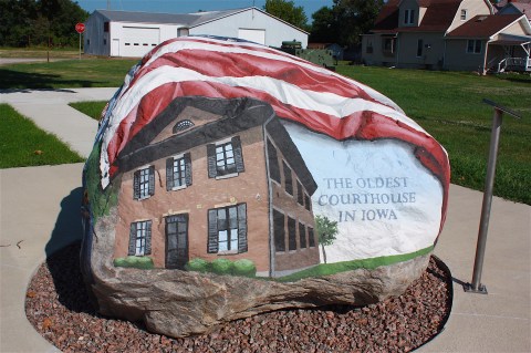
Once I figured out how to get out of Fairfield on county road H46, I drove toward Stockport, with its bright red depot and Stockport Freedom Rock, featuring the oldest courthouse in Iowa.
Back on the road, I enjoyed seeing the healthy-looking farm fields of southeast Iowa. I didn’t see much farming activity going on, but occasionally I got stuck behind a slow-moving farm implement. I sort of enjoyed those times because I could just drive really slowly and listen to NPR on Iowa Public Radio.

I’m pretty geeky when it comes to NPR. All day Friday I listened to about a million different reports and memories and behind-the-scenes stories about the 50-year anniversary of the Apollo 11 moon landing. I will admit I’d heard enough of that, so I was really excited when “Wait, Wait, Don’t Tell Me” came on the radio Saturday morning. Not only is this one of my favorite shows (for those who are not familiar, it’s a news quiz, and it’s hilarious) but this morning was especially entertaining because the “Bluff the Listener” game featured the story of Iowa’s own Jerry Foxhoven, the recently ousted director of the Iowa Department of Human Services. These two-lies-and-a-truth stories are generally based on quirky national or international news, so to have an Iowa story featured was pretty awesome. And then Mo Rocca started rapping Meredith Willson’s “The Music Man” and I could just not stop laughing. (The “true” story featured Foxhoven’s love of Tupac Shakur; he did not, in fact, hate corn.) And then Piper Kerman, author of “Orange is the New Black,” talked about how to make prison cheesecake. I was over the moon. Thank you, NPR. I heart you so much.


By the time I got to Salem, Iowa, at 9:50 a.m. it was so hot and humid that I started using my long lens exclusively, just so I didn’t have to move around as much.


I did stop and walk around the Lewelling Quaker Museum, which seemed really nice.


At Houghton, I encountered a big-ass grain elevator and a baseball game.


And then I saw a group of cyclists! Were they following the RAGBRAI route, as I was? Or just out for a morning ride? They were moving very fast, headed toward Geode State Park. I photographed them from behind, passed them, and then photographed them coming toward me. I’m sure they wondered who the hell I was.

I didn’t see any namesake geodes in Geode State Park, but I drove as far as the lake.

This lake was created in 1950 and is known for its bluegill, largemouth bass, and channel catfish. The park is popular for swimmers and hikers as well.

I was amused by this sign. It’s the little things, really.

I wasn’t aware that there was an Army ammunition plant in Middleton, but there it was, surrounded by razor wire, right across the road from a peaceful welcome sign featuring butterflies.


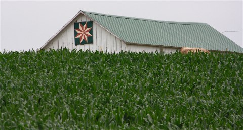
The town of West Burlington (population 2945) is, of course, located just west of Burlington, the next overnight town.


I’ve visited Burlington (population 25,663) a few times, so I pretty much knew what I wanted to see and do there. I started at the community field, home to the Class A baseball team, the Burlington Bees.


From there, I headed toward the Mississippi River to a scenic overlook:

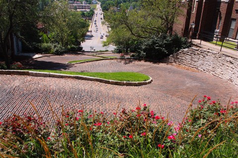
According to Burlington’s website, “Ripley’s Believe It or Not has designated Snake Alley as ‘Unbelievably Crooked’ and the #1 Odd Spot in Ripley’s Guide to the Curious Corners of America.” It continues, “Perhaps Burlington’s most famous landmark, Snake Alley … consists of five half-curves and two quarter-curves.”

It doesn’t look like much in two dimensions, does it? You really need a drone to do this street justice.
I was hoping to find lunch in Burlington, but the hills and the traffic patterns deterred me. I moved on toward my final “day” of driving.

RAGBRAI 2019, day 5: Centerville to Fairfield

After lunch in Centerville, I headed east on Highway 2, through unincorporated West Grove, arriving in Bloomfield – RAGBRAI’s day 5 meeting town.
Did I mention it was hot? I cannot imagine doing this ride on a bicycle in this sweltering weather. It’s bad enough driving the route in an air-conditioned car.


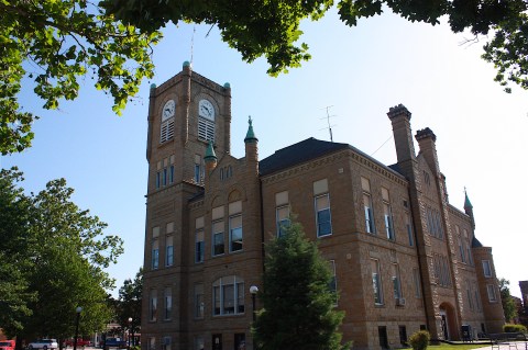
I’m particularly fond of Bloomfield. It has another one of those gorgeous county courthouses in the center of its downtown (the Davis County Courthouse, built in 1877); it’s even more ornate than most (see detail below). And there’s a bonus Statue of Liberty replica (above), the first of three I’d see on the route.


Bloomfield was definitely beautifying the downtown area and gearing up for RAGBRAI, and I noted that the town is part of the Historic Hills Scenic Byway. On my way out of town, I stopped at the Iowa Welcome Center because I’m a geek and love to stock up on the latest Iowa travel brochures. I had a nice conversation with an older woman who worked there; she gave me some advice for the next day. But I’ll get to that later.

After Bloomfield, I breezed through Troy and Lebanon (on county road J40) without stopping. Turning north on V64, I crossed the Des Moines River, which runs between Leando and Douds. Combined, the two towns have a population around 267. Here’s the bridge that connects the two towns:

The town of Libertyville (population 345) is the last stop before today’s overnight stop in Fairfield. I give this little town a lot of credit for its RAGBRAI planning. And I so wanted to stop at Peck’s Pub for a cold beer…but I needed to keep driving.


I was really looking forward to spending time in Fairfield and staying overnight nearby. Fairfield is one of my favorite Iowa towns; it’s completely unique – even out of place – in this part of the state.


Fairfield is all about culture and individuality, community and creativity…and FOOD. According to Fairfield’s promotional materials and website:
- Smithsonian Magazine has called Fairfield one of America’s best small towns
- Fairfield has more restaurants per capita than San Francisco…
- …and their eateries offer cuisine from more than 10 nationalities
- This small town of less than 10,000 people is bursting at the seams with artists of all kinds: painters, sculptors, musicians, dancers, and poets
- First Friday Art Walks are held the first Friday of the month year-round, not just in the nice-weather months. More than half a dozen art galleries are open for business in Fairfield, and the Art Walks also include music and food.

By my own observations: you can get a damn good cup of coffee here, and the shops and restaurants are actually open, some even after 5 p.m.! I could happily live in Fairfield if it wasn’t located so far away from a bigger city.

Fairfield is one of the overnight towns on the RAGBRAI route this year, and I’m sure they’re going to do it up right.


One of the big reasons that Fairfield is, well, Fairfield, is the presence of Maharishi University of Management. Since 1974, this university has offered “consciousness-based” education programs, making Fairfield an international center for Transcendental Meditation.

The Maharishi campus includes a Tower of Invincibility, plus golden domes where 1,000 people are said to gather twice daily to practice Transcendental Meditation.

Maharishi Vedic City, situated just north of Fairfield, is designed as a model of ideal city life based on the Vedic knowledge that influences the architecture, agriculture, health care, and economy of a city. I don’t know diddly-squat about this…I’m just quoting from their materials. But I did drive by, stop my car, and tromp around a bit.

The homes seem quite peaceful, painted in restful, pastel hues. And there’s a Vedic Observatory that uses a series of sun dials to map out the university according to Vedic teachings. (The historic Vedic religion is a predecessor of Hinduism and is associated with India.)
See? I told you Fairfield is unique.

Anyway, I rolled into town around 3 p.m., parked my car, and walked for a good long time around the downtown area. There is so much to see here! Another great old courthouse (with another Statue of Liberty):


I love the colorful architecture in this town, and I could not wait to eat dinner here. But first, after about an hour of walking and sweating (my car’s temperature gauge said 106 at one point), I decided to go check in to my hotel: The Rakmapura Park Hotel in Vedic City.
Now, you may wonder why I decided to stay here. This place gets iffy (at best) online reviews, but I thought it looked interesting and relaxing. I brought a swimsuit, even though I do not swim, because I thought it might be nice to cool off in the water. Unfortunately, the Rakmapura has no pool.

The hotel is located north of Fairfield by several miles, and I’m glad I had Google Maps or I would never have found the place. You go by the aforementioned Maharishi University of Management and past fields and whatnot…it’s quite remote.
When I arrived between 4 and 5 p.m., there were a few cars in the gravel parking lot, but nobody working at the reception desk. In fact, it did not appear that anyone had been working here for quite a while judging by the number of packages sitting there. My room key was in an envelope with my name on it, so I took the key and walked down to Room 4 to see what awaited me there.

The room – a suite, really – was ridiculously large for what I paid ($99 a night), which made my mind jump to all kinds of crazy conclusions, most of which I learned from scary movies (think “Get Out” and “The Shining”). The room was super nice (almost too nice?)…it had a fireplace and an oval bathtub and a mini fridge and a porch…but it just, I don’t know, gave me a vibe. I texted my family, just in case.
I was so hot and sweaty that I decided to wash up and change my clothes before going back into Fairfield for dinner. I needn’t have bothered…my new clothes were immediately soaked through after about 5 minutes in the humidity.
My information sources had indicated there would be Ethiopian food just off the square, so that was my destination. But I didn’t find the restaurant.
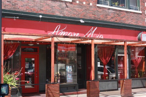
After walking (sweating) a while, I decided to have a drink at Amore Mio, which I assumed was a wine bar but was actually a full-service ristorante Italiano. The crowd that night was a bit odd – I overheard some pretty bizarre conversations while sitting at a high-top in the bar – but the service was superb, the pinot noir was inexpensive, and the pour was generous. My server kept my water glass full and even brought me some bread to munch on.


My second choice for dinner was Indian food, so I cut across the park to India Café. The restaurant was mostly empty, so the service was prompt and the food was very good. I had rich, creamy navratan korma with rice and naan, and I could only finish about half of it.

Back to Rakmapura Park Hotel, I soaked away the grime of the day in my peach-colored oval bathtub and then went to bed.

Here are some parting shots from Fairfield:


RAGBRAI 2019, day 4: Indianola to Centerville
With the start date of the actual RAGBRAI XLVII bike tour across Iowa bearing down on me, I took a vacation day and headed for Indianola, the town where I’d left off more than a week before.
By 8 a.m. I had already experienced an extremely rough road (riders, beware of R63!), encountered a detour and a confusing intersection, and may have taken the wrong route into Lake Ahquabi State Park. (Is there gravel on this route? I don’t think so.)

“Ahquabi” is a Sauk and Fox word meaning “resting place.” The 770-acre Ahquabi State Park has a 115-acre lake, sand beaches, and trails. The man-made lake is said to be good for fishing, boating, and swimming. Paddleboats are available for rent.
It was already hot and humid this morning, with a high predicted around 97 degrees – 110 if you factor in the heat index.

I didn’t stop in unincorporated Liberty Center and just kept moving until I came to Lacona (population 349). There I found some residents putting flowers in pots at the fire station department (above). I walked around the block, already sweating, and took pictures of the Willis Cabin, built in 1846.

I found a lot to like in downtown Chariton, including what would be the first of many beautiful old courthouses along this section of the bike route. I also found several signs of RAGBRAI, which would soon be passing through the town.


I meant to try to find Chariton’s popular cinder path, but I forgot.
I did not stop in tiny Millerton, population 45 in the 2010 census. I did stop to walk through a pretty cemetery on county road J22, but then continued through Bethlehem, which I’m not sure is really a town.

As I popped over hill after hill surrounded by green Iowa farm fields, it occurred to me to be grateful to the RAGBRAI planners. Without them, I would not have been on these roads, going through these towns, having this experience.
I didn’t expect much from unincorporated Confidence, Iowa, but I not only found another cemetery but also a small park.


I rarely take the extra-mileage loops on the RAGBRAI route, but this morning I made an exception. The optional Karras loop takes riders around Rathbun Lake and to Honey Creek Resort. I’ve stayed at the resort before and blogged about it, and it’s really worth going out of the way to see this place. There’s a large lodge featuring a soaring lobby, restaurant, bar, and 105 guest rooms. There’s also an indoor water park – perfect for winter travels but not truly necessary today with access to the lake – plus a golf course, cabins, trails, and more. It’s truly a gem in southern Iowa.


I didn’t stop in unincorporated Walnut City (not to be confused with Walnut, Iowa, which was on the route a few days ago), but I did find this scene in Mystic, population 405:

And then, gosh, I was already to Centerville, the next overnight town. My goal was to get here by noon, in time for lunch. I had no trouble finding a place to eat. I chose the Northside Diner because it serves breakfast all day. There’s also an all-you-can-eat salad bar, if that’s more your style.

Afterwards, I walked around the square, enjoying the architecture and the preparations for RAGBRAI.


RAGBRAI 2019, day 3: Winterset to Indianola

A few days after I drove the first two days of the RAGBRAI route, I started where I left off: in Winterset, Iowa. I had become lost on the gravel hills of Madison County at the end of that first day, but today I was fresh and ready to start again.
I knew I would find lots of opportunities in Winterset; it’s a great community (population 5,190).

The first thing I found? Corn. Not fields of corn, but actual corn you can eat, at a sweet corn stand right on the main drag into Winterset. I wheeled in there and bought a big bag from these guys:

Actually, I did one other thing before I even got to Winterset: I stopped at Covered Bridges Winery. Madison County has several wineries, and this one is right outside Winterset on Hwy. 169. I stopped by to take a few photos and was such a big fan of their logo that I almost bought a T-shirt! I like the wine names, like Francesca’s Folly (an easy-drinking blush) and Hogback Bridge (a sweet red), tasting room is modern and attractive. The winery has “Sunday Wine Down” events all summer, with free music, wine, and snacks for purchase. Given that I was driving the RAGBRAI route, I didn’t think it would be a good idea to sample the wine; I’ll wait and do that another day.


Back in the downtown area, I had already photographed the Madison County Courthouse, some of the surrounding shops, and the Iowa movie theater when I was here earlier:


I wanted to visit the John Wayne Birthplace Museum, but I did not want to pay the $14 entry fee. I’m not that enthusiastic about John Wayne.

Wayne was born Marion Robert Morrison on May 26, 1907. His home is small and tidy.


Nearby is the Winterset Freedom Rock, painted by Ray “Bubba” Sorensen. This county’s rock features many of the military films starring The Duke, which seems appropriate.

I visited Roseman Bridge on my previous visit, but you can’t be in Madison County and only visit one covered bridge, right? So I went to the Cutler-Donahoe Bridge (below), which was built in 1871 but moved to Winterset City Park in 1970. It gets my vote as easiest to get to and with the least amount of gravel. And it’s just as cool as the Roseman bridge.


On my way out of town I stopped by the Cedar Covered Bridge (below), which is famous for all the wrong reasons. It’s been the site of arson and rebuilding (both in the early 2000s), which kind of makes me sick when I think about it. It has lost much of its historical beauty.

I mentioned in the Atlantic to Winterset post that I discovered a new (to me) Iowa Byway. And now, here’s another one! The Covered Bridges Scenic Byway. This route encompasses, obviously, the covered bridges in Madison County, but also other scenic natural, cultural, and historic areas. The route is 82 miles long.

Speaking of route, today’s RAGBRAI route is historically short. Actually, if you drove straight from Winterset to Indianola, it’s just 25 miles (and 31 minutes by car). Even with the never-direct RAGBRAI route, it’s still only 39.9 miles. Today will be a breeze for the bikers, compared with the hills they had to climb the two previous days.

Once the cyclists leave Winterset, they will not encounter any towns for quite a while. They’ll actually stop at Howell’s Greenhouse & Pumpkin Patch for a “RAGBRAI OASIS” sponsored by the Iowa Soybean Association. I stopped there, too, and think this will be fun for the riders.
It’s too early for pumpkins, of course (too bad; that would be fun), but there will be some of the normal fall activities retrofitted for summer (i.e., the pumpkin cannon becomes the gourd cannon). I spoke with some of the folks there, and they said cyclists should expect food vendors, booths, and other fun activities.

I nosed around in the barn shop and greenhouse, and I watched people playing with baby goats.


I was looking forward to visiting the town of Cumming. There’s an active bike trail that goes right past Cumming Tap, so that’s a great place to see cyclists stopping off for a refreshing beverage any time during the summer. Unfortunately, Wednesday afternoon must not be a hopping time for Cumming Tap or the bike path – or the town of Cumming, for that matter – because it was very quiet.

Cumming is also home to the Iowa Distilling Company (conveniently located right across the street from Cumming Tap). And also an old, preserved gas station.


Norwalk, today’s “meeting town” on the RAGBRAI route, is mostly a bedroom community. Its proximity to Des Moines and I-35 have spurred the growth in the community from 8,945 in 2010 to 10,590 in 2016 – and more today, I’m sure. Norwalk definitely looks like a suburb, with rows upon rows of newer homes – and more being built – plus schools, churches, and other signs of expansion. That’s in contrast to its tiny main street that has seen better days.

After Norwalk, it’s on to Indianola along R63. Indianola (population 14,782) is home to the annual National Balloon Classic and to the year-round National Balloon Museum and U.S. Ballooning Hall of Fame. I’ve really enjoyed attending the balloon events in August; in fact, attending my first one about 10 years ago was the inspiration to start a blog about Iowa.

Indianola is also home to Simpson College, a small liberal arts college. The college has 1,250 full-time and 300 part-time students.
Des Moines Metro Opera, a highly regarded opera company, also has its headquarters and performance space in the heart of Indianola. I arrived the main building – the Lauridsen Opera Center – just before the staff was leaving for the day to prepare for the evening’s performance. It’s a beautifully renovated space, located in the old Indianola Public Library building, one of the Carnegie libraries that are scattered throughout Iowa. I love the photos and quotes on the walls: “World-class opera grows tall, proud in the Cornbelt,” said the Chicago Tribune; “Don’t tell anyone, but Des Moines has good opera,” writes the New York Times.


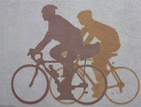
Indianola’s downtown area gets my vote (so far) for Best RAGBRAI Signage with this mural featuring cyclists in silhouette:

I didn’t visit them, but three wineries are located in and around Indianola: Summerset, La Vida Loca, and Annelise. All are open for tastings and events.
With that, I headed back to Ames. I finished today’s route just in time for rush hour.
RAGBRAI 2019, day 2: Atlantic to Winterset

I arrived in Atlantic around noon on my first day of driving the RAGBRAI XLVII route. Atlantic is the first overnight stop along the route – the sixth time the town has been selected for an overnight stop in RAGBRAI history.
I’ve driven the route some days and experienced disappointment at the lack of food resources along the way, especially when I try to stop for lunch after 1 p.m. For that reason, I’ve started bringing food with me. As I sat on a bench in downtown Atlantic, chewing my peanut butter sandwich, I saw several places to eat with their OPEN signs lit. I guess I should have checked out the possibilities before digging into my sack lunch.

Atlantic – population 7,112 and the Coca-Cola capital of Iowa – is a pretty nice little town. I found a lot to like: Thrift stores, downtown shops, movie theater, Coca-Cola museum, beautiful old homes. I thought it was funny to see a vintage Pepsi sign on one of the buildings… in this city of Coke.


Out on the highway, there are the usual chain stores and restaurants, which I always avoid. As I left town, I drove past a motel where I stayed last summer when I came to this area to celebrate a college friend’s milestone birthday.

Today’s route starts out with a quick pass through Wiota, where there isn’t much to see (sorry, Bob).
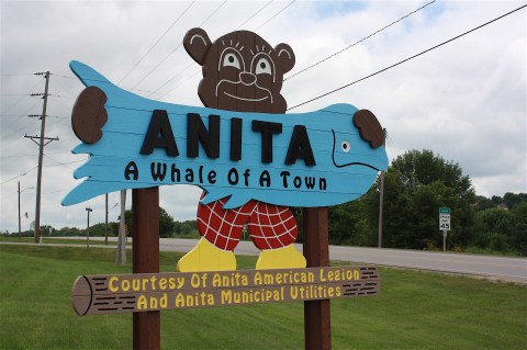
Anita, Iowa, on the other hand, has my nomination for Best Welcome Sign. It’s a cut-out of a bear wearing red-checkered pants and yellow shoes, holding a big blue fish printed with the words “Anita: A Whale Of A Town.” You’ve gotta love it, right?

For a town with fewer than a thousand residents, it’s surprising that Anita has an 18-hole golf course, a cute downtown, and a fair amount of other services and amenities.


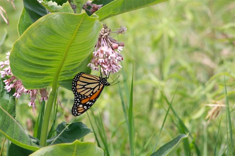
I especially like Lake Anita State Park, just south of Anita and not technically on the RAGBRAI route. I drove there, parked my car, and walked along the bike path that loops the lake. It was a beautiful day, and the lake’s edges were filled with water lilies. I also encountered birds, geese, cyclists, and flowering milkweed covered with butterflies.


I hope the nature-loving cyclists have an opportunity to experience the beauty of this state park.

Next town on the route is Adair, where I found a very large John Deere dealer, a city park, and a rooster crowing loudly at 2 p.m.

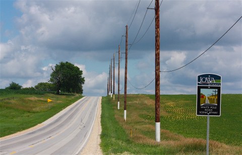
It was leaving Adair that I first noticed a new Iowa Byways sign for White Pole Road Scenic Byway. When did this happen? I thought I had driven all of the Iowa Byways, and I have a brochure that details each of them (though it is a few years old). But I didn’t know about White Pole Road.
I was interested in the history of the designation, so I looked it up. According to the Travel Iowa website, the 26-mile route, located between Adair and Dexter along old US Hwy 6, was formerly part of the route known as the Great White Way. It was lined with 700 white-painted telephone poles, linking five small towns and events from wagon times and train robberies to present day.

Well, I like this road and I’m happy to know more about its origins.


I’m guessing that a lot of Iowa towns are celebrating their sesquicentennials this year, because as I entered Casey there were signs proclaiming the 150th anniversary celebration (I’d encountered Avoca’s celebration earlier in the day). Casey’s celebration was scheduled for the next weekend, July 12-14.

I felt a strong sense of community in Casey, with its retro banners, flower baskets, and veterans’ pocket park


I got confused for the first time all day, trying to follow the RAGBRAI map to Menlo. The road signs said Hwy 25, a north/south road, and I needed to go east on county road F65. I did a number of U-turns before finally deciding to just head south on 25 and see what would happen. It turns out that the road was also F65, a fact that would have been nice to know at the intersection. But I did meet these nice horses during one of my side-of-the-road-map-reading sessions.

I got to see more of White Pole Road, too:

I had fun photographing signs and a vintage gas station in Menlo (population 342):


I have to add these fun factoids gleaned about Menlo from Wikipedia:
Menlo “hosts an annual avacado [sic] festival and lawnmower races. Turbo has won the lawnmower races 33 years stright [sic]. In 2019 Turbo extended his winning streak to 34 straight victories at the sesquicentennial celebration.” And: “Paul Bunyan was born in Menlo in 1642.” I think it’s especially chuckle-worthy that this entry misspells “avocado” and “straight” but correctly spells “sesquicentennial.” Somebody must have looked it up.
Stuart, Iowa, is the meeting town on this second day of RAGBRAI. Of all the towns I drove through today, Stuart was the friendliest. A woman walking downtown smiled and said “good morning!” then corrected herself and said “I mean, good afternoon!” We both laughed.
Stuart has an Instagram-worthy downtown and the “strictly modern” Hotel Stuart:


And then it’s on to Dexter. I clearly failed to do enough pre-travel research, because I learned when looking up the White Pole Road Scenic Byway that Dexter is home to Drew’s Chocolates, the only candy shop in the country (emphasis mine) that daily fork-dips each piece by hand.
Also, according to Wikipedia, Dexter (population 600) was the site of a shootout between members of the Bonnie & Clyde gang and police in 1933.
And now here we are in lovely downtown Dexter:


The next town on the route is Earlham, the last stop before the route turns sharply south. Up until now, as I mentioned, it’s been following that White Pole Road byway, which is due east.
Earlham is a tiny town with a hint of class, as shown by its downtown architecture and shops:


RAGBRAI’s Day 2 route ends in Winterset. As I was heading south on P57, I saw a sign for the Roseman covered bridge, built in 1883 and famous for its role in “The Bridges of Madison County” book and movie. I’ve visited the bridge a few times before, but I thought, What the heck, why not take this gravel road and shoot some photos before finishing my drive in Winterset? Here’s the bridge, which comes complete with its own gift shop:

That seemed like a good idea at the time, but after visiting the bridge I got ridiculously lost on The Never-ending Gravel Roads of Madison County. (If I were writing the book, that would be the title.) The gravel hills are like freaking roller coasters, and none of them seem to A) go any particular cardinal direction nor B) go more than about a half mile before ending at a T intersection or turning off slightly with a different road name. I gave myself a deadline to get un-lost before turning to Google Maps (oh, the horror of using Google Maps on a RAGBRAI drive!)
But I finally found (without Google) a paved road (Hwy. 169) way the hell south of Winterset. I did spend a little time in the downtown area before heading back to Ames for the night, but I’ll save that for my next blog post: Winterset to Indianola.
RAGBRAI 2019, day 1: Council Bluffs to Atlantic

It’s July, so it’s time for my annual-ish drive across the state of Iowa, following the designated RAGBRAI route. This is always a cool opportunity to get out the big Iowa map, travel along county roads and through small towns, and see parts of Iowa I’ve never seen before.
To be clear, I do this by car, not bike.
I started this year’s drive the 4th of July weekend, spending a full day driving the first two RAGBRAI sections.

The route starts in familiar territory: Council Bluffs. It takes about 2.5 hours to get there from my house in Ames, so I will admit that I only drove as far as the edge of the town to get gas at Casey’s and then turned back east on the official route. I was eager to be on my way.
Riders will experience a teensie bit of the Loess Hills right at the very beginning of Day 1 – not nearly enough, in my opinion. I think every RAGBRAI route should start with a full embrace of Loess Hills.
The beginning of the route runs parallel to Interstate 80, so close that you can see and hear it.

Driving along county road G8L, I was immediately greeted by a patriotic hay bale before rolling into Underwood, population 917.
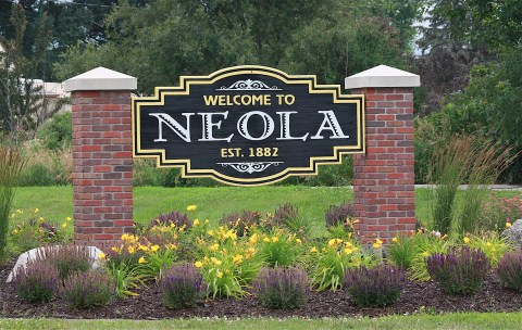
The next town, Neola, has a good welcome sign, a ball field, big American flag, and brightly painted water tower, all as you enter the town.

Continuing through Neola, I stopped at what appears to be an old movie theater. The sign says the Phoenix operated from 1913 to 2011.

I vaguely remember driving through here before, because there’s an engaging black-and-white mural of the Champlin gas station, complete with vintage cars from the 1940s. Here’s a detail:

Neola also has a bar called the Tipsy Cow, another mural – this one a salute to veterans – a church with a steeple so tall you can see it from all over town, and a small downtown area with buildings in various stages of disrepair.

Next up is Minden, with its grocery store, park, greenhouse, and fireworks stand. And a lot of American flags. (It’s 4th of July weekend, after all.)

Continuing on county road G18 toward Avoca, I encountered slow farm equipment, good-looking corn, and killer hills. To me, the hills are fun. To the bikers on RAGBRAI, they will probably be less so.


In Avoca, today’s “meeting town” on the RAGBRAI route, I inadvertently stumbled upon the town’s 150th celebration. Wow, this is a big summer for Avoca – first a sesquicentennial and then a RAGBRAI stop.

The celebration ran July 3-6, with games and a farmers market, car show, train display, scavenger hunt, barbeque, corn boil, watermelon feed, beer garden, talent show, fireworks, 5K run, pancake breakfast, swimming, kiddie parade, sand volleyball, ice cream social, food trucks, and lots more. Just thinking about the planning that goes into this kind of small-town celebration makes me tired.

The day I was there (Saturday, July 6: “Born To Be Wild” day, according to a sign in one storefront), there were a lot of bikes of a different type: motorcycles.

I was intrigued by the trivia questions in some of the store windows. Do you know what was built in Avoca in 1924 and at 250 feet long and 135 feet wide is said to be the largest in the state of Iowa? Well, I do not. (Let me know if you have the answer, because this is bugging me.)

I hated to just drive away from Avoca’s celebratory downtown, but I was eager to get to Walnut, Iowa’s Antique City. (As an editor, I cringe at this, because I’m sure that it should be “Iowa’s Antiques City,” right? The city’s not an antique; it has antiques stores. Anyway, sorry to digress.)
I love antiques, so I’ve been to Walnut several times before. If you are NOT an antiques lover, you might want to avoid this town, because that’s pretty much the only thing here. A few images for you:


I poked through a few of the shops and managed not to spend any money. I did enjoy just perusing the storefronts, murals, and other visual details. They are clearly starting to prepare for RAGBRAI here in Walnut (population 785).


The land around Walnut is pretty: hills, curves, corn, wind turbines. After leaving Walnut, I drove through Marne (population 115) without stopping, even for one photo. Perhaps I was too hasty. Marne has a darn nice website, touting the town’s “convenient location between Omaha and Des Moines” and its proximity to I-80. There’s apparently a beautiful park with tons of amenities. How did I miss this? My favorite thing about the website? Pictures of pie. Marne’s slogan, if you’re curious, is “From a proud past to a promising future.” All I know is that I slowed down a bit, looked left, looked right, and then noticed that the speed limit had gone back up.
Wow, today went by quickly on four wheels – I’m sure it will feel a lot longer on two. I got to Atlantic (population 7,112) around noon. I’ll tell you more about it in my next post: Atlantic to Winterset.
Sequoia and Kings Canyon

Well, after Yosemite you’d think these two lesser-known California national parks would disappoint. But I really loved this area.
First of all, it’s much less crowded. Secondly, we had an awesome lodge, as opposed to the fantastically placed but outdated Yosemite Valley Lodge. We took some great hikes, climbed Moro Rock, saw bears, and got to (literally) hug some truly massive trees.

Sequoia and Kings Canyon are two national parks, but they’re sort of packaged together. The visitor guide and all the brochures are together, and entrance fees are combined.
We arrived in the afternoon after spending the morning in Yosemite, so we got a fairly late start. We drove the Kings Canyon Scenic Byway, stopping to take photos at scenic vistas and to take a couple of short hikes:


We were very tired when we arrived at our overnight, Wuksachi Lodge, located in Sequoia National Park.

We didn’t have dinner reservations and there were no tables to be had in the dining room, so we sat in the bar and ordered food off the menu. Tonight, we slept well.
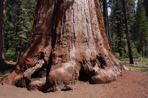
The next day we drove the Generals Highway to our destinations: Sherman Tree Trail, Moro Rock, and sequoia trees so large and famous that they’ve been given their own names.
We loved the giant trees and the relative solitude of the hiking trails. At times, we were alone among the trees. Other times, we were hiking with just a few other people. We walked through meadows and along streams and through the oldest living trees on the planet.
How many pictures of trees do you want to see? Probably not very many. They all look pretty much alike. And not one of them really shows how freaking cool these trees are in real life.


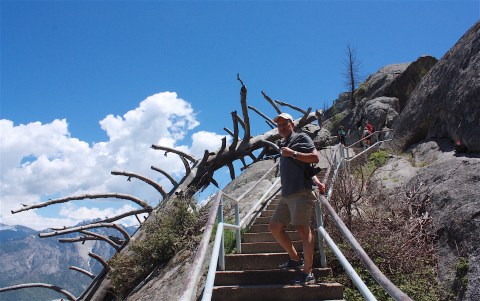
Hiking Moro Rock (above) was a fun experience. Also strenuous and a little bit scary and ultimately invigorating. Here are some photos from the trek to the top:


On one hike, we encountered marmots, which look like a beaver without the big, flat tail. I think they’re exceedingly cute.

We also got our first bear sighting of the trip! We’re told these two were probably juveniles, but they seemed HUGE to me.


We had a relaxing evening on the patio, eating pizza with a bunch of people we just met.

The next day, we ended our visit to Kings Canyon and Sequoia with a walk through Grant Grove.

Here are some parting shots:


Yosemite National Park

I’ve always had this vision of Yosemite that made it seem otherworldly, untouchable. Like somewhere I’d never get to actually see. It was for people with money and connections and serious climbing gear. In my mind, it was a combination of Ansel Adams’ pristine photography and a valley so crammed with tourists that the line of cars would stretch forever. The idea of Half Dome seemed completely inaccessible to me, and I couldn’t even imagine El Capitan. I thought the park would be impossibly large. All of these things were contradictory and confusing. I clearly didn’t know what to expect.
After spending four days in the park, I have such an intense love for this place that I can’t believe I was so conflicted about it. Yosemite’s beauty goes far beyond anything I’ve experienced in the National Park System – except in Alaska. It was approachable, easy to navigate, and filled with happy people – but not so full that the people and cars overshadowed the nature. For me, Yosemite was a land of surprises.
I’ll start at the beginning. We arrived at the west entrance gate the first morning and were ready to dive right in. We thought the park would be so large that once we got to the valley we wouldn’t get back to this point, so we explored the immediate area.

Based on a recommendation from a park ranger, we started with a hike at Merced Grove, famous for its giant trees. We were prepared to hike in Yosemite – we brought hiking shoes, sun protection, rain gear, water, camera equipment, backpack, hiking sticks, you name it – but we left most of it in the rental car. It was a pretty day, and the hike was only a couple of miles along a well-marked path.
Well, you already know where this is going, right? Things change. Weather is tricky. We were about halfway to the end of the grove when we heard the first clap of thunder. We made it to our destination – a stand of huge trees – before it started raining, but then we had to hike back. Oh, and did I say “rain”? It was actually hail. So much hail that my hair was filled with ice and the trail was white and we were super wet and freezing cold and the word “hypothermia” crossed my mind.

Welcome to Yosemite. Land of surprises, indeed.

But the freak storm ended and we dried off and took another hike in nearby Tuolumne Grove to see more mind-blowingly-large trees (above). This time we carried more gear, which of course we did not need.
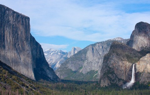
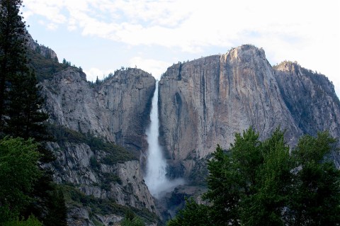
After a picnic lunch, we drove into Yosemite Valley and were blown away by one spectacular sight after another: Our first look at Half Dome. The imposing El Capitan. Yosemite Fall. Bridalveil Fall. The rushing white-water rapids of Merced River. Sentinel Bridge. The famous “Tunnel View” where you can see Half Dome and El Capitan and Bridalveil Fall all at the same time.
Well, I should just shut up and show you the pictures:


We did all this sight-seeing before we even checked in to Yosemite Valley Lodge, our home for the next three nights. It was an incredible day. Maybe the best day EVER. I was so stoked to be staying in Yosemite Valley, with Yosemite Falls pounding behind our lodge, that I didn’t even care that our room was tiny and probably furnished in the 1970s. We found a bar within our “village” that served good beer and surprisingly good food and called it a night.
Oh, and today was Dave’s birthday.
Day 2
The next day we left our car in the parking lot and took off on foot. We wanted to hike and explore and take the shuttle buses wherever we needed to go.

We had a whole list of hiking trails we wanted to attempt. We started with a hike at Mirror Lake, with its views of the surrounding peaks (above). Apparently it’s not really a lake but just part of Tenaya Creek. Anyway, the hike is just an easy two-mile loop but we didn’t end up doing the whole thing because the signage confused us.

We meandered around and took the Mist Trail to Vernal Fall and tromped around Lower Yosemite Fall and got wet with a couple hundred goofy tourists with selfie sticks.


We walked through meadows and watched deer – they are as tame as dogs, these deer – and hung out at the Yosemite Museum and Ansel Adams Gallery. I think we overdid it the first day, because we were really tired.
We chose our lodging – Yosemite Valley Lodge – because of the location and because it was considered moderately priced. There are other lodging choices in Yosemite: Campgrounds are cheaper; The Majestic Yosemite Hotel is very pricey; Big Trees Lodge is cool and historic but located a long way outside the valley. I wanted to at least visit the Majestic and Big Trees, so we decided to eat meals at both places.
Tonight we ate a disappointing dinner at the cafeteria in our village and had more beers in the bar.
Day 3

We had a breakfast reservation at the Majestic the next morning. It was a Sunday. Our reservation was early, but we knew the shuttle buses would be running. We put on our nicest clothes and waited at the shuttle stop. We waited a long time. An older man was waiting with us, and he was complaining loudly about how slow the shuttle service was. According to him, just two buses start circulating at 7 a.m. (many others are added later). One bus is supposed to go one direction, the other bus the other direction. There are about 20 shuttle stops, and it takes a long time to make the whole loop. He theorized that both buses went the same direction. And he was right. Long (boring) story short, we waited so long for our shuttle to pick us up that we ended up walking to the Majestic (me wearing shoes not made for trail hiking) only to be passed by BOTH of the shuttle buses going the same direction. I was very cold and irritated by the time we got to the hotel (half an hour late), but the enormous dining room seemed really warm and welcoming. Until they told us the buffet would cost $56 per person and sat us, literally, in between two waiter stations even though there were a gazillion other available tables. (In hindsight, why did I not ask to move to a better table?) Luckily, we could order food from the menu, so we weren’t stuck with a $135 breakfast bill. I ordered The Continental, which ended up being some fruit and coffee and juice a plate filled with such amazing little pastries that I forgot all about being pissed off and just enjoyed it. (See the hotel’s historic interior, above.)


Our destination for the day – Hetch Hetchy – required our car, so we caught the shuttle back to our lodge, changed clothes, and drove out of the valley. The Hetch Hetchy reservoir (above) provides drinking water and hydroelectric power to the city of San Francisco and was the site of some serious controversy between John Muir and Teddy Roosevelt (spoiler alert: the president won). It’s a beautiful area, but we didn’t think it was nearly as pretty as the valley. We were planning to hike the trails around the reservoir, but once we crossed the O’Shaughnessy Dam we encountered standing water on the trail that would have filled our shoes. We considered doing the hike anyway but ultimately decided were unwilling to get our feet that wet for a walk that didn’t look all that interesting.
We had talked to a park ranger the day before about going up to Glacier Point, a destination south of the valley that isn’t far as the crow flies but is a fairly long drive down and around and up a mountain. He said there was snow on the peaks, with a potential for wet, snowy trails. After our disappointment at Hetch Hetchy, we had plenty of time on our hands, so we cut our losses and headed for Glacier Point anyway.
As we drove up the mountain, we did indeed see a lot of snow on the sides of the road. Some of the side roads were actually blocked off because of deep snow. And it was raining by this time, so we had sort of low expectations for the Glacier Point lookout.
Hoo, boy, were we wrong. Turns out there were a lot of crazy people who drove up the mountain in the rain, and they were all hanging out up there getting soaked. We found a place to park and decided the rain was light enough that we should just hike up to see the view before the weather got any worse.
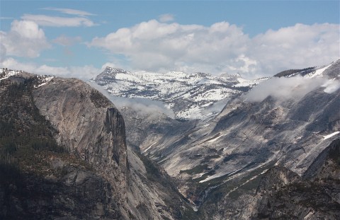
Our first glimpse at our surroundings took our breath away. We pulled our rain jackets over our cameras and started shooting. Every few yards the view became more spectacular. By the time we got to the top, it was just unbelievably gorgeous. The low clouds just added to the dream-like atmosphere. Eventually, as we stood there with our mouths hanging open, the sun came out and we had to shoot everything over again because it looked completely different. How many pictures can you take of a snow-kissed Half Dome? It turns out A LOT.
Again, just shut up and show the pictures.


For a day that started off with an overpriced breakfast, bad service, and an iffy reservoir, today ended up being another Best Day Ever.
We eventually stopped taking pictures and saying “WOW” over and over and headed back to our car. On the drive back down the mountain, the road was covered with new snow. At the intersection at the base of the mountain, we learned that our 45-minute-ish drive back to the valley would be a tiny bit longer. The road was closed due to mudslides. (Apparently this happens.) We could wait an indeterminate length of time to see when (if) the road opened back up, or we could take the very long route south and west then north and east back to the main entrance. It took for freaking ever. Maybe three hours. But the drive along the Merced River back into the valley almost made up for it. Almost.
We were really ready for our evening beer.
Day 4
The next morning, we checked out of our lodge and drove south in the park to Mariposa Grove of Giant Sequoias. If I remember my John Muir history right, this was one of the first places he sought to have preserved as a national park-type area, before Yosemite was a national park.

We took the Mariposa Grove Trail and the Grizzly Giant Loop Trail and took more pictures of large trees than were strictly necessary, especially considering that we were headed next to Sequoia National Park, home of the most giant of giant trees.

After we had our fill of large trees, we doubled back a bit into the park to eat lunch at the aptly named Big Trees Lodge. I was hoping to dine on the wrap-around veranda, but we were served in the dining room instead. Still, it was a nice meal.

So, that’s my Yosemite experience. If you go, I have a couple of pieces of advice: First, stay overnight in the valley. You won’t regret it. And plan your trip a year in advance if you can, because even though it seems like there’s plenty of lodging in the valley, it fills up very quickly, especially during the summer months. Also, if you go too early in the season, just be aware that many of the roads will be closed. We were there at the very end of May / first of June and Tioga Road to Tuolumne Meadows (an area I would have loved to see) was still closed. Glacier Point Road had just opened before we got there.
Here’s a lovely thought: Maybe someday I’ll go back in the fall.

Exploring San Francisco’s National Park sites

For my husband, Dave’s, 60th birthday in late May, he wanted to do nothing more than visit National Park Service attractions in California. His number-one goal was to see Yosemite National Park, but we were able to cram in half a dozen more for good measure.

We started in San Francisco with a ferry to Alcatraz – yep, the former U.S. penitentiary on Alcatraz Island is run by the Park Service. And it’s surprisingly popular. We saw boat after boat heading to the small island in the bay.


The now-defunct prison has a fascinating history, from the Birdman to attempted escapes to Al Capone. I learned about the American Indian occupation in the 1960s, of which I was previously unaware, and about the families of the correctional officers who lived on the island.


The cellhouse itself not as cool as the Eastern State Penitentiary Museum in Philadelphia, but it’s interesting. And the views of San Francisco are outstanding.

Of course, while we were there on Fisherman’s Wharf, we walked around, ate a couple of meals, and barked at the sea lions.


The next day, we drove to Eugene O’Neill’s home in Danville. Tours of the famous playwright’s last home, Tao House, are given a couple of times a day. The isolated home is situated on a hillside, and you have to drive through a few gates to get there, so you meet the park ranger downtown and ride up with him.

On this particular day, we were the only visitors, so we had a nice chat with the guide and actually found out we had friends in common in Illinois. Small world. Anyway, O’Neill is most famous for his plays Ah, Wilderness!, The Iceman Cometh, and Long Day’s Journey Into Night. He is a four-time Pulitzer Prize-winner. The house and its remote setting are worth a visit:


That afternoon we visited another home, this one belonging to the famous conservationist John Muir in Martinez, Calif.

Muir has been called the father of national parks, and he worked tirelessly to preserve America’s wild lands. He’s closely associated with what is now Yosemite National Park and with his influence on President Theodore Roosevelt.
Here’s the house and some of the interiors:


After seeing Muir’s home and watching a film about his life, we were inspired to visit Muir Woods National Monument in Mill Valley, north of San Francisco.

It’s a peaceful, wonderful place. We took a hike through groves of redwoods, many of them more than 600 years old.


We were lucky to be able to visit Muir Woods, because you have to get a reservation in advance – and this was a spur-of-the-moment decision. Luckily, there’s an app and we were able to snag a time. I’m so glad it worked out.
