RAGBRAI 2019, day 2: Atlantic to Winterset

I arrived in Atlantic around noon on my first day of driving the RAGBRAI XLVII route. Atlantic is the first overnight stop along the route – the sixth time the town has been selected for an overnight stop in RAGBRAI history.
I’ve driven the route some days and experienced disappointment at the lack of food resources along the way, especially when I try to stop for lunch after 1 p.m. For that reason, I’ve started bringing food with me. As I sat on a bench in downtown Atlantic, chewing my peanut butter sandwich, I saw several places to eat with their OPEN signs lit. I guess I should have checked out the possibilities before digging into my sack lunch.

Atlantic – population 7,112 and the Coca-Cola capital of Iowa – is a pretty nice little town. I found a lot to like: Thrift stores, downtown shops, movie theater, Coca-Cola museum, beautiful old homes. I thought it was funny to see a vintage Pepsi sign on one of the buildings… in this city of Coke.


Out on the highway, there are the usual chain stores and restaurants, which I always avoid. As I left town, I drove past a motel where I stayed last summer when I came to this area to celebrate a college friend’s milestone birthday.

Today’s route starts out with a quick pass through Wiota, where there isn’t much to see (sorry, Bob).
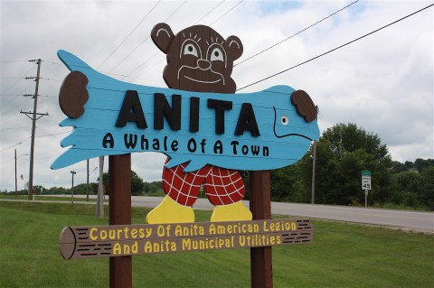
Anita, Iowa, on the other hand, has my nomination for Best Welcome Sign. It’s a cut-out of a bear wearing red-checkered pants and yellow shoes, holding a big blue fish printed with the words “Anita: A Whale Of A Town.” You’ve gotta love it, right?

For a town with fewer than a thousand residents, it’s surprising that Anita has an 18-hole golf course, a cute downtown, and a fair amount of other services and amenities.


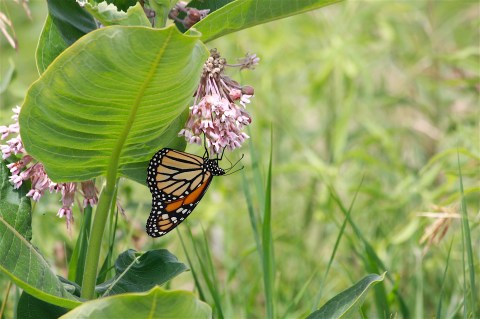
I especially like Lake Anita State Park, just south of Anita and not technically on the RAGBRAI route. I drove there, parked my car, and walked along the bike path that loops the lake. It was a beautiful day, and the lake’s edges were filled with water lilies. I also encountered birds, geese, cyclists, and flowering milkweed covered with butterflies.


I hope the nature-loving cyclists have an opportunity to experience the beauty of this state park.

Next town on the route is Adair, where I found a very large John Deere dealer, a city park, and a rooster crowing loudly at 2 p.m.

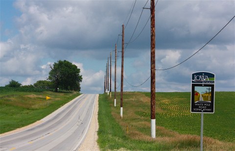
It was leaving Adair that I first noticed a new Iowa Byways sign for White Pole Road Scenic Byway. When did this happen? I thought I had driven all of the Iowa Byways, and I have a brochure that details each of them (though it is a few years old). But I didn’t know about White Pole Road.
I was interested in the history of the designation, so I looked it up. According to the Travel Iowa website, the 26-mile route, located between Adair and Dexter along old US Hwy 6, was formerly part of the route known as the Great White Way. It was lined with 700 white-painted telephone poles, linking five small towns and events from wagon times and train robberies to present day.

Well, I like this road and I’m happy to know more about its origins.


I’m guessing that a lot of Iowa towns are celebrating their sesquicentennials this year, because as I entered Casey there were signs proclaiming the 150th anniversary celebration (I’d encountered Avoca’s celebration earlier in the day). Casey’s celebration was scheduled for the next weekend, July 12-14.

I felt a strong sense of community in Casey, with its retro banners, flower baskets, and veterans’ pocket park


I got confused for the first time all day, trying to follow the RAGBRAI map to Menlo. The road signs said Hwy 25, a north/south road, and I needed to go east on county road F65. I did a number of U-turns before finally deciding to just head south on 25 and see what would happen. It turns out that the road was also F65, a fact that would have been nice to know at the intersection. But I did meet these nice horses during one of my side-of-the-road-map-reading sessions.

I got to see more of White Pole Road, too:

I had fun photographing signs and a vintage gas station in Menlo (population 342):


I have to add these fun factoids gleaned about Menlo from Wikipedia:
Menlo “hosts an annual avacado [sic] festival and lawnmower races. Turbo has won the lawnmower races 33 years stright [sic]. In 2019 Turbo extended his winning streak to 34 straight victories at the sesquicentennial celebration.” And: “Paul Bunyan was born in Menlo in 1642.” I think it’s especially chuckle-worthy that this entry misspells “avocado” and “straight” but correctly spells “sesquicentennial.” Somebody must have looked it up.
Stuart, Iowa, is the meeting town on this second day of RAGBRAI. Of all the towns I drove through today, Stuart was the friendliest. A woman walking downtown smiled and said “good morning!” then corrected herself and said “I mean, good afternoon!” We both laughed.
Stuart has an Instagram-worthy downtown and the “strictly modern” Hotel Stuart:


And then it’s on to Dexter. I clearly failed to do enough pre-travel research, because I learned when looking up the White Pole Road Scenic Byway that Dexter is home to Drew’s Chocolates, the only candy shop in the country (emphasis mine) that daily fork-dips each piece by hand.
Also, according to Wikipedia, Dexter (population 600) was the site of a shootout between members of the Bonnie & Clyde gang and police in 1933.
And now here we are in lovely downtown Dexter:


The next town on the route is Earlham, the last stop before the route turns sharply south. Up until now, as I mentioned, it’s been following that White Pole Road byway, which is due east.
Earlham is a tiny town with a hint of class, as shown by its downtown architecture and shops:


RAGBRAI’s Day 2 route ends in Winterset. As I was heading south on P57, I saw a sign for the Roseman covered bridge, built in 1883 and famous for its role in “The Bridges of Madison County” book and movie. I’ve visited the bridge a few times before, but I thought, What the heck, why not take this gravel road and shoot some photos before finishing my drive in Winterset? Here’s the bridge, which comes complete with its own gift shop:

That seemed like a good idea at the time, but after visiting the bridge I got ridiculously lost on The Never-ending Gravel Roads of Madison County. (If I were writing the book, that would be the title.) The gravel hills are like freaking roller coasters, and none of them seem to A) go any particular cardinal direction nor B) go more than about a half mile before ending at a T intersection or turning off slightly with a different road name. I gave myself a deadline to get un-lost before turning to Google Maps (oh, the horror of using Google Maps on a RAGBRAI drive!)
But I finally found (without Google) a paved road (Hwy. 169) way the hell south of Winterset. I did spend a little time in the downtown area before heading back to Ames for the night, but I’ll save that for my next blog post: Winterset to Indianola.

Leave a comment