Springtime on the Superior Hiking Trail

My love affair with the Superior Hiking Trail in northeastern Minnesota continues.
I’ve been traveling to this area of the country for 17 years now – a total of more than 20 separate trips. On most of these trips, I’ve traveled alone. It’s such a treat to be able to clear my mind and hike on these beautiful, remote trails for a few days – and then, each night, eat good food and sleep in a comfy cabin.
Back in the early days, I always got up early and hit the trail, hiked all day, and fell into bed exhausted. As I got older and more out of shape, I slept later, hiked gently, read good books, and drank wine. Both approaches were quite enjoyable. Within the past couple of years, I’ve improved my fitness level, and on my latest hike (June 2-4) I spent more time hiking and actually tackled more challenging trails.
It takes about 8 hours (from Ames, Iowa) to get to the north shore of Lake Superior. It’s a straight shot up I-35 to Duluth, and then a lovely drive along lakeshore-hugging Hwy. 61 – all the way to Canada, if you want to go that far north. I usually enjoy watching the temperature drop slowly as I drive north, but on Friday the temp stayed around 85 degrees well into northern Minnesota – until it dropped dramatically to 55 degrees within a period of about 15 minutes as I reached Duluth. And it stayed cool and comfortable the whole time I was up there.
I took four separate hikes on the SHT. I’ll talk about these in the order I hiked them:

OBERG MOUNTAIN
This 1.8-mile loop is a great leg-stretcher, with easy access and nine scenic overlooks. It can be incredibly beautiful in the fall, but it was also pretty this spring, with green green green in every direction.


To get to the Oberg Loop hiking trail, turn onto Onion River Road at Hwy. 61 milepost 87.5 and drive 2.2 miles to the big parking lot on the left side of the road.
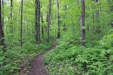
ALFRED’S POND
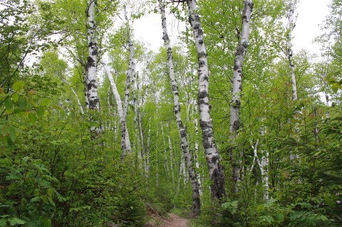
Officially, this 9-mile section is called “Caribou River Wayside to Cook County Road 1,” but I just think of it as the Alfred’s Pond hike. It’s one of my favorite hikes on the whole SHT. And the cool thing about this section is there’s another trailhead about a third of the way through, so you can park there and only be about 2.3 miles from the pond. That’s what I did.
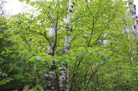
The trail was lined with lovely birch trees with their early spring leaves, and so many wildflowers that I spent much of my hike taking pictures. I can identify some – trillium and marsh marigolds are my favorites – but others are just, well, pretty spring wildflowers. Here are a few:
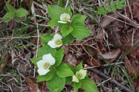

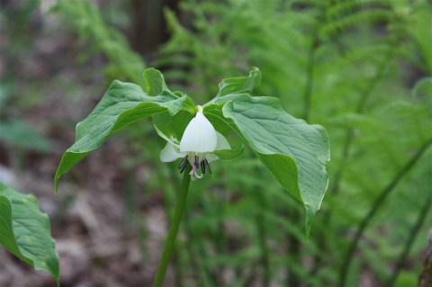
It began to rain lightly while I hiked. I could hear it hitting the trees above me, but I really wasn’t getting wet until I got to Alfred’s Pond and left the forest canopy. I popped my poncho on over my head and sat quietly on the bench at the end of the walkway to the pond, just drinking in the aching beauty of that remote location. There were no people anywhere – just me and the lake and the trees and the rain. It was so beautiful it almost made me cry. But instead I smiled, grateful for the experience.


To hike this trail section, park at the Caribou River Wayside trailhead right on Hwy. 61 at milepost 70.5. Or to get to Alfred’s Pond without walking quite so far, take Sugarloaf Rd. at milepost 73.3 and drive 1.5 miles to the parking lot on the left.
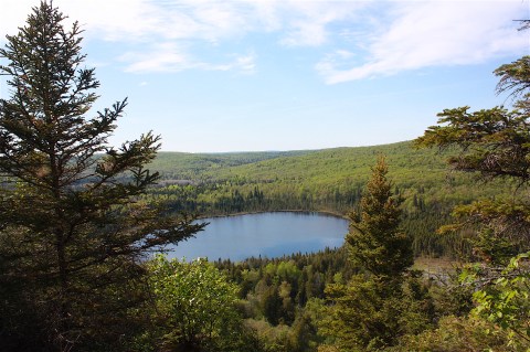
BEAN & BEAR LAKES
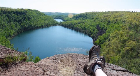
I don’t know why I’ve been obsessing lately about the Bean & Bear Lakes hike. I did it once, years ago. I remember that the hike was tough but the lakes were beautiful. Maybe I just wanted to challenge myself. Anyway, I hiked this “Twin Lakes Trail” on Saturday afternoon. I parked at the Bay Area Historical Society in the town of Silver Bay; a 2.3-mile spur trail takes you to a loop trail with dramatic views of the twin lakes.

The spur tail was muddy, rocky, and not particularly scenic. I was happy to get to the main event: the section with views of the lakes. It’s worth the time it takes to get there:

This section is part of the main SHT; however, once I started heading back toward Silver Bay I noticed a severe shortage of signs telling me where I was and I started to worry. It was late in the day and I couldn’t afford to get lost. I didn’t see a trail sign or a human being for a long time and just counted on my instincts to be hiking on the right trail.

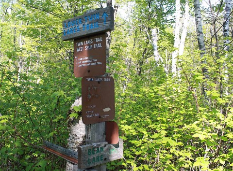
And I was – up to a point. I hiked right back to Silver Bay on the SHT, somehow without ever turning onto the spur trail. (You can see the confusing signage above.) So when I popped out in the town, I was nowhere near my car. Interesting! I don’t think this has ever happened to me. I walked and walked and walked and walked along a roadway, hoping it was the right one and I’d eventually find my car. Of course, I finally did – it’s a small town, after all – and I was never so happy to see my little orange Prius waiting for me at the local historical building.
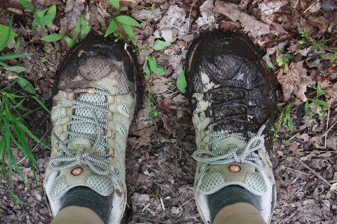
I think the hike itself was about 7 miles (with lots of mud and scrambly ups and downs), plus I think I walked a couple of miles in town. All I know is my feet hurt, and the beer and pizza that night in Grand Marais tasted mighty good.
To do this hike, turn at the Hwy. 61 stoplight at Silver Bay around mile marker 54.3 and drive to the historical building on your right or, better yet, drive along Penn Blvd./Outer Drive for a really long way until you get to the trailhead parking on your right. Try not to get lost.

TOWER OVERLOOK
From Cook County Road 1, I hiked north with the goal of arriving at Tower Overlook within an hour. I didn’t count on the boot-sucking mud and slippery creek crossings, which made the trail a bit of an obstacle course. But it was a pretty hike, with an outstanding variety of spring wildflowers. Here are some of them:


The whole trail section is 8 miles long, ending at Temperance River State Park, but I turned around after a couple of miles once I got to the overlook. I didn’t see a single person on this section. Ahhhhh! But I did see a very small toad and trash my hiking shoes.

To get to this section, turn left on Cook C. Rd. 1/Cramer Rd. at the Hwy. 16 milepost 78.8 and drive 3.6 miles to the parking lot on the right.
THE REST
I stayed two nights, as usual, at Cascade Lodge, located on Hwy. 61 between Lutsen and Grand Marais. I like Cabin 2, but there are other cabins and a lodge from which to choose. I ate breakfast at Cascade Restaurant, which sort of feels like going to grandma’s house I’ve eaten breakfast there so many times. They have the best blueberry pancakes ever.
I ate lunch on Friday in Two Harbors at the Vanilla Bean Café. They have an awesome wild rice burger. And, as per my usual routine, I ate dinner both nights in Grand Marais, once at Gunflint Tavern and once at Sven & Ole’s Pizza.
I love this place and can’t wait to go back.

Leave a comment